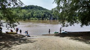
Anglers
Located between Billy Goat Trail Sections A and B and just downstream from Widewater is Anglers, one of the most visited sections of the C&O Canal. The natural beauty of Anglers provides the perfect backdrop for walkers, hikers, bikers, kayakers, birders, fishermen, photographers, and painters alike. However, to Canal engineers, Anglers posed a problem: rock.
Just upstream from Anglers, canal engineers decided to put an old river bed of the Potomac to good use. They constructed a wall on either end of Bear Island with over 50 feet of dry laid stone, and then inundated the area with water to establish present-day Widewater.
At the downstream end of Widewater, the problem began. They were met with rocky outcroppings which extended all the way to the shores of the Potomac. Rather than navigate the waters of the river, the engineers decided to blast off the rock to create an area suitable for canal construction. By doing so, they exposed several rock formations which otherwise would have remained hidden, including one of the most visible synclines in the entire park. A syncline is a downward fold of rock where the layers of the different rock strata are easily identified. The syncline at Anglers is just below the downstream end of Widewater on the opposite side of the canal from the towpath.
The rocks that were blasted off at Anglers were incorporated into a dry-laid stone wall between the towpath and the river which still stands and can be seen today. Recent explorations of the wall reveal that it is between 9 and 12 feet thick at the top, 16 to 25 feet thick at the bottom, and anywhere from 16 to 21 feet high. Such construction is quite an undertaking using modern construction practices. One can only imagine what the laborers of the 1830s must have gone through to construct the wall. Even more amazing is that it stood for almost 180 years before a portion collapsed in 2008.
Unfortunately, the wall did not solve the canal company's problems in this area. In many areas of the park, the canal was built directly on bedrock. At Anglers, blasting the rock to provide an area for the canal meant, ironically, that in some places, there was no rock directly under the canal. Rather, a portion of the canal here at Anglers was built on compacted earth. Recent explorations have indicated that competent rock, especially in the area of the current breach, was found as deep as 42 feet below the bottom of the canal.
Over time, this area of the canal fell victim to numerous heavy rain and flood events which washed away the compacted earth, and took the towpath and a portion of the historic wall with it. In recent times, Anglers has been impacted by the torrential rains of Hurricane Agnes in 1972, the floods of 1996, and Tropical Storm Hanna in September 2008. It was this storm that caused the current 125-foot breach in the towpath just upstream from Anglers Bridge. To provide for the continued visitor enjoyment of the area, a "bypass" towpath was constructed temporarily around the breach.
Less than a month after the breach, the C&O Canal Trust launched a $100,000 campaign for the repair of the towpath. These funds helped the C&O Canal National Historical Park rebuild the missing 125 feet of towpath, reconstruct the historic stone wall, and improve drainage to mitigate the heavy rains which have long plagued the area. Now that construction is complete, the canal at Anglers will be filled again with water, and visitors will again be able to marvel at the natural beauty while walking the historic alignment of the canal and towpath. With so much to offer for the walker, the hiker, the biker, the kayaker, the bird watcher, the photographer, and the painter, Anglers deserved nothing less than a return to its historic glory.
Add to Itinerary
You can now create your own itineraries to guide your C&O Canal exploration, or you can copy one of ours! Lean more about Itineraries.

Photo by William James
Nearby Amenities:
- Anglers Canoe/Kayak Ramp
Approximately 0.1 miles away.  Anglers Parking
Approximately 0.1 miles away. Anglers Restrooms
Approximately 0.1 miles away.- Old Angler's Inn
Approximately 0.1 miles away. - Widewater
Approximately 0.5 miles away.


