All Roads Lead to Cumberland
By Ranger Rita
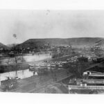
Cumberland may be the end of the C&O Canal, but it was also once known as the "Gateway to the West." The Potomac River cuts through the mountains in and around Cumberland, providing one of the easiest westward crossings.
In the 1750s, settlers heading west began using the Cumberland Narrows route. It was still a slow and arduous trek over the mountains. In 1811, the Cumberland or National Road was built and movement of goods and people became easier. Finally, starting in 1828, the B&O Railroad and the C&O Canal raced to Cumberland in an effort to reach the Ohio River with an even more efficient transportation system. The B&O Railroad pulled into Cumberland in 1842, followed by the C&O Canal in 1850. By the late 1800s, Cumberland had grown into the second largest city in Maryland largely because of its key location at the junction of the National Road, the C&O Canal, and the B&O Railroad. All roads led to Cumberland.
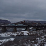
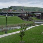
Today, from the canal towpath at its terminus in Cumberland, you can easily get the sense of Cumberland's importance as a transportation hub. At this location, you have a great view of the Narrows to the west and just across Wills Creek from the terminus is the beginning point of the National Road. The Western Maryland Scenic Railroad rolls past on train tracks over top the canal inlet locks. These tracks were laid by the Western Maryland Railway in the early 1900s, not the mighty B&O. Highway traffic snakes through the city overhead on I-68.
In 2011, Cumberland is celebrating two important anniversaries - C&O Canal National Historical Park's 40th and the National Road's 200th. A transportation forum is part of the National Road anniversary celebration, slated for September 10, 2011, in Cumberland. As part of the event planning committee, I hope you will join us for conversations on Cumberland's continuum of transportation- road, water and rail- and their respective impacts on the city's past, present, and future.
Hopefully one day soon, your road will lead you to Cumberland.
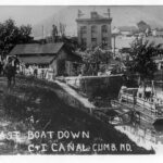
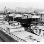
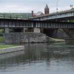
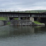
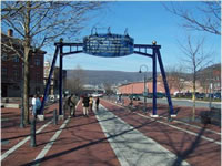
- This photo from the 1890s shows boats waiting at the basin at the canal’s terminus with the Cumberland Narrows in the background. Credit: Chesapeake & Ohio Canal National Historical Park
- The last boat down the Canal, at least where the canal was able to hold water, left the Cumberland Terminus in the summer of 1936. Credit: Chesapeake & Ohio Canal National Historical Park
- The terminus of the canal was not only the site of loading boats with their coal cargo but it was also the site of many of the boat building enterprises that catered to the canal boatmen. New boats and repairs to old boats took place at multiple boat yards similar to this one. Credit: Chesapeake & Ohio Canal National Historical Park
- This winter view of the Cumberland Narrows at dusk greets towpath users as they reach Mile 184.5 of the canal. The Narrows was known as the Gateway to the West and the National Road was re-routed through the Narrows in the late 1830s. Credit: Chesapeake & Ohio Canal National Historical Park
- Re-watered inlet feeder lock area at Cumberland Terminus. The Scat Eaton house was situated here during canal shipping days and removed in 1958 when the Cumberland-Ridgeley Flood Control Project was built. The Eaton family were inlet guard keepers for the canal company, similar to lock keepers or tenders. Credit: Chesapeake & Ohio Canal National Historical Park
- A railroad line crosses over top the canal inlet lock. This is a more modern rail connection dating to the 1950s. In the background is the old West Virginia Central Railroad line, now used by the Western Maryland Scenic Railroad. Often confused with the Shriver Basin coal loading area, this is not the location where coal was dropped into waiting canal boats. The Shriver Basin was slightly south and east of this site. Credit: Chesapeake & Ohio Canal National Historical Park
- Modern view of beginning point of Cumberland or National Road on Greene Street. Credit: Chesapeake & Ohio Canal National Historical Park
- Long view over top the canal basin at Cumberland with the Narrows in the background and the Celtic cross – a tribute to the Irish canal and railroad builders – in the foreground. Credit: Chesapeake & Ohio Canal National Historical Park
C&O Canal Terminus
Milepost 184.5
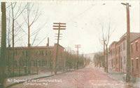
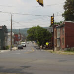
National Road Mile 0
Milepost 184.5
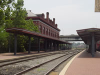
Western Maryland Railway Station
Milepost 184.5