Preserving the Canal
By Ranger Lisa
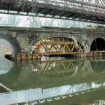
I find it exciting to stand at the edge of the newly restored Catoctin Aqueduct, its white stone glistening in the sun. I came often during the restoration process to see the painstaking work of putting the aqueduct back together, stone by stone. Now, walking across this amazing structure, rebuilt mostly with its original stones, I marvel at the dedication of the people who made this possible.
Known as the "Crooked Aqueduct," because boaters had to make a sharp turn to enter, the Catoctin Aqueduct's structural integrity was dubious from the beginning. The elliptical center arch was not as structurally strong as the semicircle arches on either side and the aqueduct began sagging in the early 1900's. It leaked constantly and was prone to flooding, further undermining its reliability. In 1973, just two years after Congress established the C&O Canal National Historical Park, two arches collapsed, leaving only a remnant of the eastern arch standing.
The park service salvaged and buried the original stones to help preserve them in case the aqueduct was ever restored. Community support for the project kept building. Finally, in 2007, the park entered into an agreement with the Catoctin Aqueduct Restoration Fund, Inc., to raise the funds necessary to restore the Catoctin Aqueduct. Their grass roots effort, including an Adopt-A-Stone program, raised over $2.5 million dollars. An American Recovery and Reinvestment Act grant in 2010 provided the remaining funds necessary to complete the project.
Four hundred and fifty nine original stones were uncovered and used in the restoration. Each was like a puzzle piece in a 3-dimensional puzzle, having its own unique position and role. The park's engineering crew measured each stone and cut out foam patterns on the outer edge of the aqueduct. Historic photos were then used to identify where individual stones were positioned. Missing stones or those in poor condition were replaced. In a little over a year, construction was complete. Today, new viewing areas and waysides allow visitors to learn about the structure and the efforts to rebuild it.
I invite you to visit the new and improved Catoctin Aqueduct and ponder the sweat and love that went into making it possible for us to once again enjoy its bright white stones shining in the afternoon light.
-
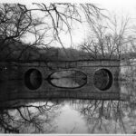
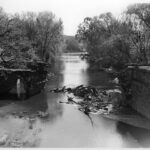
- The Catoctin Aqueduct, with its elliptical center arch, was still mostly standing when this photograph was taken in 1971. The opposite berm wall had already collapsed and the center arch was in danger of collapse. In 1973, the aqueduct collapsed into the stream and the National Park Service would span the gap with a modern bridge. Credit: J. Rottier Collection, Chesapeake & Ohio Canal National Historical Park
-
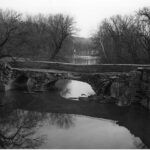
- View of the collapsed berm wall of the Catoctin Aqueduct in 1971. Credit: J. Rottier Collection, Chesapeake & Ohio Canal National Historical Park
-
- View of the collapsed center and west arch of the Catoctin Aqueduct in 1973. Credit: K. Quinn Collection, Chesapeake & Ohio Canal National Historical Park
-
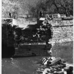
- View of the debris pile and the remaining west wing wall of the Catoctin Aqueduct in 1973. Credit: K. Quinn Collection, Chesapeake & Ohio Canal National Historical Park
-
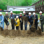
- On August 7 2010, a groundbreaking ceremony for the rehabilitation of the Catoctin Aqueduct was held. Numerous contributors helped raise money for the restoration project. Credit: C&O Canal National Historical Park
-
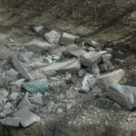
- The aqueduct’s original stones were buried after the 1972 collapse and saved for the future. Engineers used historic photos to determine where these stones would be placed. If it could not be determined where the stone was to be placed, a new stone would fill that space. New stones were cut from the Patapsco Quarry. Credit: C&O Canal National Historical Park
-
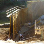
- Construction on the aqueduct had many phases. This image shows excavation for the piers which had to be sunk into the ground. Credit: C&O Canal National Historical Park
-
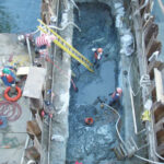
- A retaining wall was built to keep water out of the construction area. Credit: C&O Canal National Historical Park
-
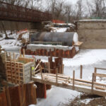
- Arch forms were built from lumber and served as the support for arch construction. Credit: C&O Canal National Historical Park
-
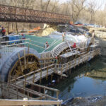
- Stone for the arches was meticulously placed on the arch forms. Original stones were placed according to historic photos with new stones filling in. Credit: C&O Canal National Historical Park
-
- When the arches were completed, the wooden arch forms were removed leaving the arches free-standing. This is the first time since the collapse in 1972 that the arches have stretched over Catoctin Creek. Credit: C&O Canal National Historical Park
-
- Catoctin Aqueduct Credit: CHOH NPS
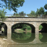
Railroad Viaduct
Milepost 51.5
Lander Lockhouse
Milepost 50.9

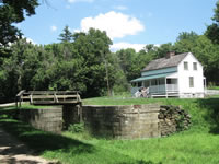
Lockhouse 28
Milepost 50
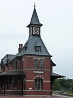
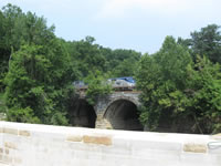
Point of Rocks
Milepost 48.2
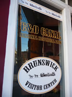
Brunswick
Milepost 55